| Participant number | Short name of participant | Person months per participant |
|---|---|---|
| 1 | SWRI | 10 |
| 2 | CERTH | 11.8 |
| 3 | MGRE | 7 |
| 4 | THL | 5 |
| 5 | CUT | 6.5 |
| 6 | POLIBA | 17 |
| 7 | FST | 7 |
| 8 | MEU | 7 |
Objectives
• To demonstrate the outcomes of the previous research-oriented WPs to MEDSAL test sites; thus, evaluate, verify and optimize the initially developed tools, techniques and methods.
• To develop and real-time monitoring and alerting network for salinization.
• To identify latent patterns and proxies for salinization with high-frequency measurements and machine learning techniques.
• To model groundwater salinization and assess the potential risk, based on simulated forecasts and anticipated climate change impacts.
• To develop and suggest tailor-made management plans for the coastal aquifers of the case studies.
Description of work
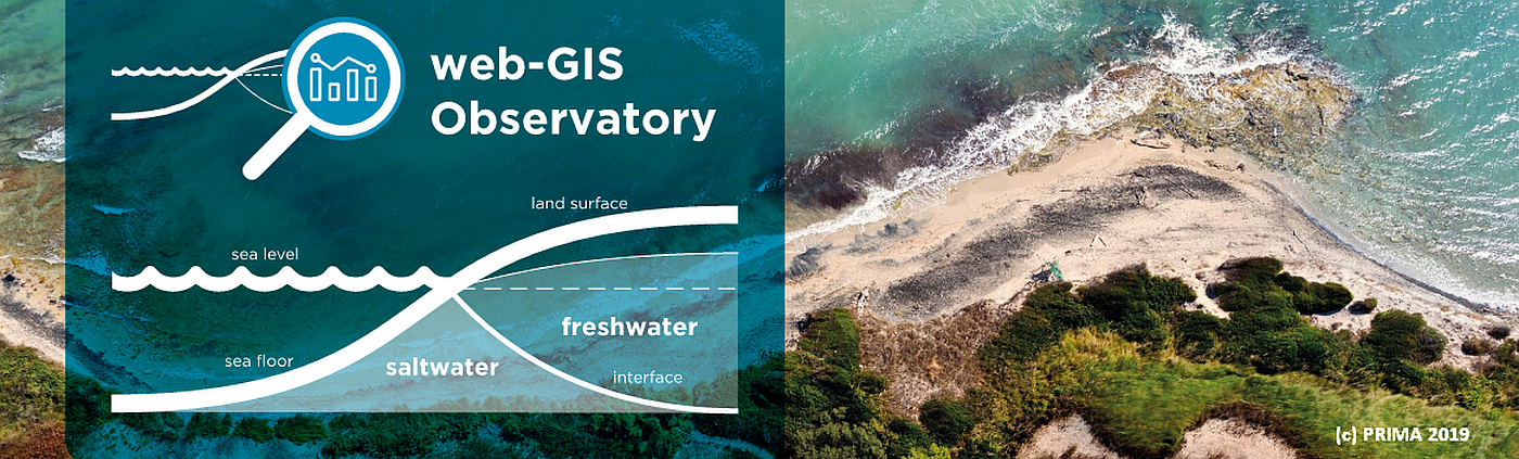
This WP intends to apply, test and evaluate the developed integrated MEDSAL tools/methods in the 6 case study areas, aiming to simulate salinization and forecast the evolution of the phenomenon. Based on the individual case site characteristics (e.g. hydrogeological conditions, data availability, etc), the experts of Project’s partnership have initially suggested the potential tools/methods to be applied in each site (see T5.3). However, the initial work plan may be re-adjusted if needed, based also on the feedback received by D4.6, to apply the optimal per site techniques for GWS simulation. Results will provide feedback for customized (per site) risk assessment of GWS and suggested management plans, considering the potential impacts from the anticipated climate change phenomenon; thus, assessing salinization in a dynamic and multi-parametric way. In addition, WP5 includes the installation and operation of multi-parametric sensors, in support of real-time alerting and monitoring. The recorded high frequency measurements (e.g. 15 min interval) will be used to identify salinization proxies with the use of deep learning techniques. WP5 outcomes will be visualized through dynamic maps and will be uploaded to the MEDSAL web-GIS Observatory, demonstrating the use of a public domain tool for stakeholders with enhanced abilities.
| WPs | Tasks | Leaders | PPs Involved | Duration |
|---|---|---|---|---|
| T5.1 | Alerting and monitoring of salinization with telemetric multi-sensors | POLIBA | POLIBA, THL, FST, MEU, MGRE, SWRI | M1-M6 |
| T5.2 | Development of salinization proxies: Application of Machine Learning to high-frequency records of multi-sensors | CERTH | CERTH, POLIBA, SWRI | M6-M34 |
| T5.3 | Application of MEDSAL Integrated methodologies: Simulation and forecasting of salinization in MEDSAL test sites | POLIBA | M22-M28 | |
| T5.4 | Climate change projections and induced impacts on aquifer salinization at MEDSAL Test Sites | SWRI | M24-M30 | |
| T5.5 | Risk assessment and customized management plans | THL | M28-M34 |